Arguably the most significant planning decision in the city's recent history took another step forward Thursday night.
City staff presented its updated preferred Clair/Maltby Secondary Plan boundaries at a special meeting of City Council.
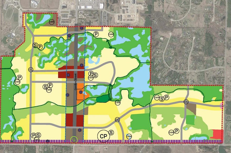
That plan, more than two years in the making, guides how the area south of Guelph between Clair Road and Maltby Road will evolve over the next 25 years.
The land use plan includes everything from where high/medium/low density housing can go, where commercial development should be allowed and where proposed parks and schools will eventually be.
It now moves to the June 25 meeting of council for final debate and vote. If approved, staff will move forward with the third and final phase of the project, with the plan's completion expected in spring of 2019.
"It is a big decision for our community. It's a big issue," Mayor Cam Guthrie said at the end of the meeting that lasted just over five hours.
There were two recent changes to the plan, which has been two years in the making: (1), the Rolling Hills neighbourhood, a large upscale residential area bordered by Clair Road to the north and Victoria Road to the east, is no longer part of the plan and its land-use future will be assessed separately later; and (2) a proposed north/south road planned for just east of Gordon Street that would have cut through a proposed cultural heritage property, has been removed.
Nineteen delegates had their say, staff explained its rationale and council asked questions and offered opinions.
Much of the discussion revolved around the fact that some technical studies that were part of phase II of the plan had not yet been completed.
Several delegates wanted the process slowed down until some technical studies were finalized.
Senior city planner Stacey Laughlin said the Clair/Maltby Secondary Plan work done to date contains "a level of of detail that goes beyond the typical."
Laughlin said the "sequence is still happening as intended" and agreed with a question from councillor Mark MacKinnon that there was nothing wrong with the procedure of the work.
Coun. Leanne Piper asked how decisions could be made without all the data that might have an impact on those decisions.
Mike Marcolongo, whose family farm has been at the centre of some of the debate regarding the Clair/Maltby Secondary Plan, urged greater transparency and the need to wait for all environmental Phase II studies before moving on to Phase III.
"Trust is a two-way street .... the optics aren't great," Marcolongo said. "For us it's about a transparency issue."
Council later made an amendment to enhance community engagement and awareness moving forward, noting that it had made great efforts to do that throughout the process.
A new coalition of concerned parties has also formed.
The Protect Our Moraine is made up of seven groups: Nature Guelph, Wellington Water Watchers, Families for Rolling Hills, Speed Valley Chapter of Trout Unlimited Canada, Guelph Urban Forest Friends, Architectural Conservancy of Ontario, Guelph-Wellington, Foundation for the Support of International Medical Training (the Marcolongo family).
A member of that group will be on the city's technical advisory group or community advisory group.
The Rolling Hills community was well represented among the delegates.
Samantha Lamont of the Rolling Hills neighbourhood group, said they want assurances that Rolling Hills will remain outside the plan.
Council also heard from people representing developers who have bought up large chunks of farmland in the area in anticipation of future growth south.
Robin-Lee Norris, acting as agent for one of those developers, a numbered company, said that there were concerns about parks and schools being identified on the plan already, whereas they should be more "potential" locations.
"There are concerns that the process remains flexible," Norris said, adding that the language in the terms of reference for the project talk of potential locations, but the plans don't use that terminology at this point.
"It doesn't say they're potential," Norris said.
Council, with staff's support, later made an amendment that put the word "potential" in the plans.
Her client would like to see the schools and park locations removed from the plans until a later stage, or at least identified more clearly as "potential" locations.
She said her clients just want to make sure that everyone's definition of flexible is the same.
Hugh Handy, a planner representing several developers that own land south of Clair Road, took some heat from councillor Mike Salisbury, who questioned why some of Handy's clients weren't being "fully cooperative" with access to their properties for testing, which is within their right.
"The optics are bad," Salisbury said.
Handy said several developers are doing their own testing and they are not being confrontational in their choices.
Later, Laughlin said that property owners are providing city staff with data they are collecting themselves.
"Many are participating in a different way," the city planner said, "providing data for our use."