Retired University of Guelph science professor Reggie Y Lo and his wife Lisa share their experience of hiking one of their dream locations, Coyote Butte North, also known as The Wave, in Arizona.
On a sunny day in May, I logged into the Bureau of Land Management website to enter the online lottery for a permit to hike Coyote Buttes North, known as The Wave. I selected three dates during the last week of September, entered two hikers, paid the fee, and waited.
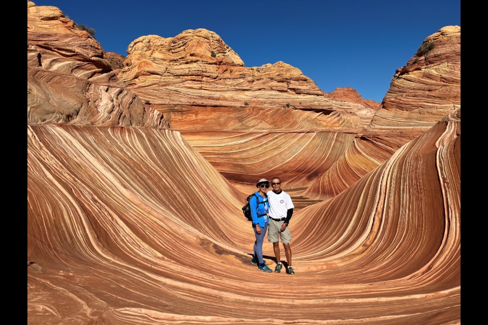
The Wave, located in Arizona, is probably one of the most sought after hiking destinations in North America, if not the world, ever since it was used as a desktop wallpaper in the 2009 Windows update.
To avoid overuse, BLM has designed a lottery system to issue limited number of permits to hike The Wave. Only 20 permits (max 64 hikers) are issued per day. Sixteen permits by online lottery four months prior and four permits by a daily draw.
My wife Lisa and I love to hike, something I inherited from my dad.
Our previous hikes include: Angle's Landing and Virgin river hike in Zion National Park, Yosemite, Canyon Land National Parks, Kauai, Hawaii and Plains of the Six Glaciers in Lake Louise.
On the morning of June 1, I received an e-mail from BLM: “Congratulations, you have been awarded a permit to hike Coyote Buttes North on September 26”. I clicked onto the link to accept the permit. A couple of weeks later, I received a mail package from BLM which contained the permit, a map with pictures of landmarks during the hike, a checklist of items to bring, a safety note on the symptoms of dehydration and heat stroke, and an invitation to attend the orientation meeting in Kanab the day before our hike.
On Sept. 24, we flew from YYZ to Las Vegas, picked up our rental car and drove to Kanab where I rented a vacation house for a couple of days. Our drive to Kanab took us from Nevada through Arizona and Utah a couple of times, causing our phone to switch an hour back and forth as these states have different time zones.
Next morning, we attended the orientation meeting where they checked our permit and described the many aspects of the hike. This included: the road condition to the trail head, items to pack, safety precautions, and emergency contacts in case we got lost. They also emphasized the importance of preserving the pristine condition of The Wave, e.g. hiking poles must have rubber tips.
After the meeting, we drove out to the trail head down House Rock Valley Road. This road is unpaved, with lots of potholes, sandy and rocky. It becomes muddy and almost impassible after rain. Fortunately, it had not rained two weeks prior, and I had rented a high clearance SUV. We did see someone drove down the road in a Mustang, the driver wisely turned back about five min in.
I took this drive out not only to check out the road condition, but to hike Wire Pass/Buckskin Gulch, two slot canyons that start from the same trail head as The Wave. We spent five hours through the hike and saw about a dozen people.
On the day of our hike, we left our rental house round 7 a.m. and arrived at the parking lot just before 8. After signing in the daily log book, we began our hike down the wash to The Wave trail. About 10 minutes into the hike, we encountered a marker erected by BLM: “Coyote Buttes North, permit required beyond this point”.
We did encounter, on two occasions, BLM volunteers who inquired about our physical wellbeing and whether we have sufficient water, snacks etc. Their main objective is to inspect our permit which they cross checked with their list (and number of hikers). I do not know what happens if there are more hikers than listed on the permit. They may invalidate the permit or ask the extra hikers to leave immediately. We were told during orientation that trespassers could be fined up to $10,000.
Once on top of the hill, we brought out our hiking poles as we were walking over slick rock. The directions provided by BLM, with pictures illustrating the route were quite easy to follow in spite of the fact that there was no defined trail. Once in a while, we turned around to observe some features on the return direction and took a picture as a reminder.
The scenery was spectacular, various formations with yellow and brown stripes. Every turn brings out another stunning visual sight; The Wave may be the renowned location, the hike is just as spectacular.
The last section up a slick hill was a bit strenuous as the sand made the footing quite slippery. It was more challenging on the return when gravity adds to the difficulty.
It took about two hours to reach The Wave, it was everything we expected and more. It boggles the mind to comprehend how the different layers of rock formations were contorted by natural forces over the eons. We spent three hours exploring the area to observe the amazing formations.
Around 1 p.m., we decided to hike back. It took longer than two hours as we were getting tired and it took more effort to walk on the rock and sand. After signing out on the log book we took the slow drive out. It would be almost 5 p.m. when we returned to our rental house. It was an exhausting day and well worth it.
Now that we have done the hike, it gave me a different perspective when I watch the many videos other people put on the internet. I would definitely make plans to return to The Wave again.
Not sure where we will go next, perhaps Crater Lake or somewhere in Death Valley.


