As a heritage study of the former reformatory lands nears, city council is set to weigh in on what’s to be considered for protection and what isn’t, with staff recommendations supported by Yorklands Green Hub and Heritage Guelph.
Determining the study boundary is a precursor to seeking designation of a heritage conservation district under the Ontario Heritage Act.
“We’re happy with that. It’s been kind of an odd process, but so far, so good,” said Alex Smith of Yorklands Green Hub, a non-profit corporation dedicated to the repurposing of part of the former reformatory and creation of a sustainable environment centre on the property.
“I think they’ve done a pretty good job of defining the boundary.”
Council is expected to consider approving the study boundary during its March 21 planning session. That meeting, which is set to begin at 6:30 p.m., is available for people to attend in person at city hall and will be streamed online at guelph.ca/live.
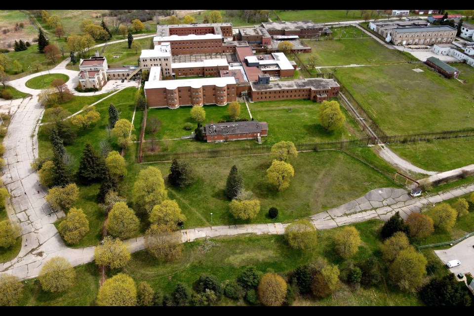
A map of the proposed study area is included above.
In general, it runs along York Road on the north end, follows the property line of 785 York Rd. and around the Cargill plant to the east, cuts along the Eramosa River and across the top of exposed quarry faces, then along the west side of a southern access road and across Stone Road East to include the McQuillan’s bowstring bridge.
The draft boundary then turns northwest along the east side of the Guelph Junction Railway right of way to rejoin with York Road.
The study is intended to assess the physical design, historical/associative and contextual value of the area; identify contributing and non-contributing properties and features; and define a heritage conservation district boundary for council’s formal consideration.
During its meeting last month, Heritage Guelph approved a motion supporting the staff-recommended study boundaries.
Wetlands along the northeast side property are proposed to be excluded from the study area.
In a presentation to HG, Stephen Robinson, the city’s senior heritage planner, explained “direct associations could not be made with the overall OR (Ontario Reformatory) lands,” which is why that slice of the property was excluded.
A previously released draft showed the former Royal City Jaycees Park area excluded from the study area but Robinson said it was added in response to “consistent feedback” from the public calling for it to be included.
The former park area “contains some cultural heritage value in its built heritage features such as a stone/concrete weir and stone-lined edge in that part of Clythe Creek,” Robinson noted.
“I’m please to see that the city and the consultant were alive to that feedback and included that.”
Staff is recommending several heritage attributes of the former reformatory lands be included in the HCD. They include:
• Organization of the area as a whole into a hierarchy of spaces and functional uses;
• Location of the main reformatory complex at the top of a hill with open areas and clear sight lines;
• Clustered thematic uses;
• Interconnected historic buildings;
• Functional qualities of the HCD area that are associated with the prison use including the placement of the administration building and an internal loop system of basement level and
above-ground passages between buildings providing alternative access and observation points for staff;
• Quadrangle arrangement of the main structures resembling an educational institution;
• Beaux-Arts design attributed to architect John M. Lyle and the City Beautiful movement;
• Residential appearance of Willowbank Hall (formerly the engineer’s residence) and the superintendent’s residence;
• Public and internal road and trail patterns within the HCD boundary;
• Ornamental landscape features including the stone walls, fences, stairs, gates, terraced gardens, gate posts, and bridges;
• Mature tree plantings;
• Ponds and watercourses;
• 919 York Rd. (Matthews farmhouse) a single-storey stone residence with hipped roof; stone shed outbuilding; stone gate on York Road leading to Matthews farmhouse and the original north access road to the reformatory buildings;
• “The Rocks” - former Ontario Reformatory quarry area (now part of 80 Dunlop Dr.) consisting of three quarry faces and remnant mining infrastructure;
• Reformatory wood trestle railway bridge over the Eramosa River;
• and McQuillan’s Bridge, a single-span bowstring arch bridge carrying a footpath over the Eramosa River; “1916” date stamp located on the cross brace.
City council endorsed the idea of initiating a CHD study regarding the former reformatory property in June of 2021. It also agreed to designate individual aspects of the site under Part IV of the Ontario Heritage Act.
The deadline to register as a delegate or make a written submission for council to consider during its March 21 meeting is March 17 at 10 a.m. To register, visit guelph.ca/delegation, call 519-837-5603 or email [email protected].